
We know that the Japanese Engineers were expert[1] bridge builders. The TBR required nearly 700 bridges – small, medium or large, wood or iron – to complete.
In the 1940s there were reportedly no bridges across the Mae Klong River. All crossing were accomplished by ferry or boat. Recently, a Thai language document has been uncovered that speaks of a bridge in the ChukaDon area just south of the walled city of Kanchanaburi. This raises two areas of speculation. It is thought that there was a spur[2] in that area from the main railway that allowed supplies to be delivered to the river bank. Such supplies would then be loaded onto barges and carried up the Kwae Noi River to the work camps. Could a bridge have been placed there at some later date? Might this have been a site that the engineers were considering to place the railway bridge? Reportedly they explored a number of sites before settling on the Tamarkan area.
There is also a map depicting a bridge in the Tadan area (between Tamarkan and Latya). POW accounts tell us that they were taken to that area and ferried across the river. Could a bridge have been placed there at some later date?
Then there is the very interesting map by AUS Lt. Flaws. He was tasked with documenting many of the original POW burial sites. Many of those maps do not contain any surviving landmarks and none seem to be drawn to scale, making them hard to validate. But there is no reason to doubt their accuracy. Those that can be correlated to existing sites are quite accurate. When he drew a map of the burial site near the two railway bridges, he also drew in a third road bridge downstream.
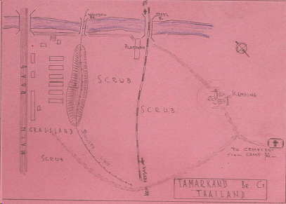
There is no other documentation of such a bridge found in any other accounts! Was Lt. Flaws wrong? Or was he the only one to make an accurate record? His maps were drawn in the immediate post-war period. In a situation parallel to that at ChukaDon, we know that the general area where he places this bridge also contained a ferry crossing. On the far bank of the river there is an arcing spur that joined with the tracks running off the two rail bridges.
Today, there is indeed a road bridge named the Sud Chai Bridge[3] that crosses the river just downstream from the remaining iron bridge. The roadway that leads west off the bridge follows a wide arc that would suggest that it was laid directly over the 1940s rail spur! Might that current bridge have been built to replace the WW2 era bridge that Flaws depicts? Why did the modern Thai engineers pick that precise location to build a bridge? There are no significant feeder roads in that area.
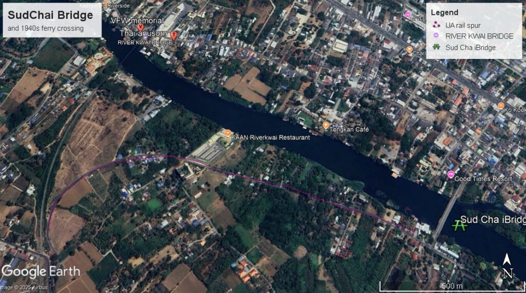
If indeed the modern bridge was built on the site of an earlier bridge – likely built by the Japanese late in the war – might there be engineering plans or notes to describe any early bridge remnants that were replaced (and likely destroyed) during the construction of the existing bridge. One might go so far as to suggest that divers explore that area looking for any pilings or artifacts of an earlier bridge.
Similarly, there is an existing modern bridge at Tadan. Might there be archived notes concerning a prior bridge?
[1] Notwithstanding the fact that they used the USARMY Merriman Manual as a template for these bridges.
[2] That spur departed the main line near where the current Post Office and McDonald’s buildings are today.
[3] Even considering that these maps are not to scale, this depiction is too close to the rail bridges for it to be the ChukaDon Bridge. That would be considerably farther downstream.