A Brief History of Kanchanaburi[1]
Kanchanaburi (KAN) occupies a distinctive place in the history of western Thailand. Its location at the meeting of the Khwae Noi, and Mae Klong and later the Khwae Yai rivers made the area important for settlement, transportation, trade, and defense. Over many centuries, the character of the city changed in response to the political and economic circumstances of the region. It developed from a frontier and military settlement into a fortified city, then into a multicultural commercial community centered on Pak Phraek. During World War II, its strategic importance returned on an international scale when the Japanese Army made Kanchanaburi a major base for the construction of the railway linking Thailand with Burma and the detention of Allied prisoners of war and romusha.
The history preserved in Kanchanaburi Old City is therefore much broader than the wartime story for which the modern city is internationally known. The surviving temples, roads, commercial buildings, city-wall remnants, riverfront areas, and communities of Pak Phraek represent successive periods in the city’s development. The Old City remains a living part of KAN rather than simply a collection of historical monuments.
From Early Settlement to a Frontier City
Human occupation in the Kanchanaburi area extends deep into prehistory. Archaeological evidence indicates continuous human activity from the Paleolithic, Mesolithic, Neolithic, and Metal Ages, with remains found in rock shelters, caves, and along riverbanks. The rivers that later shaped the historic city were already important elements in the settlement and movement of people through the region.
KAN subsequently developed as an important frontier area between the central plains of Siam and the routes leading west toward Burma. Its geographical position gave it a military importance that continued through successive periods of Thai history. The area around present-day KAN was connected with military movements and campaigns, particularly during periods of conflict with Burma.
The older KAN settlement was located at Lat Ya, west of the present city. During the late Ayutthaya and early Rattanakosin periods, the region remained associated with military activity and frontier defense. The history of the area was consequently shaped not only by permanent settlement but also by the movement of armies through the western frontier.
The military character of KAN is reflected in the history of Wat Chai Chumphon Chana Songkhram, the Royal Temple commonly known as Wat Tai[2]. The temple is believed to date to the Ayutthaya period, and historical accounts associate an old chedi at the temple with military forces assembling there before campaigns against Burma. According to the tradition recorded in the historical study, returning forces rebuilt the chedi after successful campaigns. When the deteriorated chedi was dismantled in 1946 because of river erosion, human remains were found inside and were believed to belong to Thai warriors who had died in earlier conflicts.
Another important landmark is Wat Thewa Sangkharam, the Royal Temple known as Wat Nuea2. Local tradition associates its establishment with the aftermath of the Burmese capture of Ayutthaya in 1767. According to that tradition, a monk who had been taken to Burma later returned to Thailand and established the temple near the relocated settlement at Pak Phraek. Whether interpreted as historical tradition or as part of the community’s inherited memory, the story demonstrates the strong connection between the temple, the city’s relocation, and the region’s long history of conflict and movement across the western frontier.
The Relocation to Pak Phraek
The decisive transformation of KAN occurred during the reign of King Rama III (1824–1851), when the city was moved from its former location at Lat Ya to Pak Phraek. The relocation reflected both military and economic considerations. The former city had repeatedly been exposed to Burmese military movements and had become difficult and impoverished. A larger city was therefore established at Pak Phraek, in part because of its more favorable position for trade toward Ratchaburi.
The new settlement was constructed as a fortified city. Historical evidence indicates that the city was enclosed by a rectangular wall approximately 500 meters long, with the wall rising approximately four meters and incorporating battlements. Gates were positioned around the enclosure, while a moat protected three sides of the city; the western side was protected by the river. The fortifications were designed to provide the new city with a defensible perimeter appropriate to its frontier position.
The construction of the walls and forts was undertaken rapidly. Over time, the fortifications deteriorated and many of their elements collapsed or disappeared. Nevertheless, the surviving traces of the city wall remain important historical evidence of the physical form of nineteenth-century KAN. The present City Pillar Shrine[3] also preserves an inscription describing the construction of KAN, its walls, and its forts at Pak Phraek.
The relocation also initiated a new phase of population growth. Vietnamese settlers were brought into the area following military campaigns during the reign of Rama III, with some establishing homes on rafts along the Khwae River [author’s emphasis]. Chinese migration into Pak Phraek also increased. These communities became an important part of the social and commercial development of the new city.
The former settlement at Lat Ya gradually lost its importance. By the time of King Chulalongkorn’s reign (1868–1910), the old city there was described as deserted, confirming that the relocation to Pak Phraek had become permanent. An ancient map from the reign of Rama III records both the former city at Lat Ya and the new settlement at Pak Phraek.
Pak Phraek: From Military Settlement to Commercial Community
The new settlement gradually ceased to be simply a military settlement and developed into a thriving commercial community. Pak Phraek’s position beside the rivers was fundamental to this transformation. The Khwae Yai and Khwae Noi rivers converge in this area to form the Mae Klong River, ; however, the upper course now known as the Khwae Yai was historically regarded as part of the Mae Klong and was not officially designated Khwae Yai until 1960.
By the nineteenth century, Pak Phraek had become a recognizable market district. King Chulalongkorn’s account of his 1877 visit provides a valuable description of the community. He landed at Wat Nuea and traveled along the road associated with the market, observing houses behind tall bamboo fences and noting the presence of Chinese and Vietnamese residents. Tobacco was the most prominent commodity, accompanied by ceramics, leather goods, fresh produce, and Chinese medicines. Tobacco from the area became widely known as “Pak Phraek tobacco.”
Trade encouraged the growth of a distinctive built environment. Early buildings were strongly influenced by Chinese commercial architecture, reflecting the presence of Chinese merchants and the city’s connections with trade from China. Later, as merchants traveled increasingly between KAN and Bangkok, Bangkok architectural influences became more apparent. Chinese craftsmen in masonry and carpentry and Chinese laborers also contributed to the changing appearance of the community. Four principal building forms became recognizable: shophouses, half-masonry and half-timber buildings, row houses, and detached houses.
The result was a multicultural urban environment in which architecture, commerce, religion, and everyday life developed together. Chinese and Vietnamese communities established religious[4] and commercial institutions, while Thai religious sites continued to provide important centers of community life. The Old City consequently preserves evidence of several overlapping cultural influences rather than a single architectural or social tradition.
River transportation remained fundamental to the city’s economy. Before the development of modern roads, the Khwae Yai, Khwae Noi, and Mae Klong rivers carried agricultural products and commercial goods. Logs and bamboo were floated downstream, while goods were distributed to other areas. Buildings along the river-facing side of Pak Phraek Road consequently included passages between structures that allowed goods to be moved and loaded and provided access to river landing places.
This relationship between river, market, road, and buildings is central to understanding the historical character of Pak Phraek. The city was not simply constructed beside the rivers; its economic life developed because of them.
Kanchanaburi and World War II
Kanchanaburi’s strategic importance returned dramatically during World War II. The Japanese Army sought to move forces through Thailand toward Burma and undertook the construction of a railway from Nong Pla Duk in Ban Pong District, Ratchaburi Province westward across the entire Province of Kanchanaburi to the western frontier then to Thanbyuzayat in Burma.
This transformed KAN once again into a strategic military center. The Old City became directly involved in the wartime infrastructure. The Japanese established camps and occupied or rented numerous buildings in the historic city for headquarters, offices, and commercial purposes. Pak Phraek railway station became an important station for railway construction, while camps were established to accommodate and detain the large numbers of Allied prisoners of war[5].
The wartime presence also affected the ordinary commercial life of Pak Phraek. The historical study notes that the district became a place where consumer goods used during the war were traded. The community that had grown through nineteenth-century commerce was therefore drawn into the economic and logistical system created by the Japanese occupation.
One of the most significant individuals associated with wartime KAN was Boonpong Sirivejjabhandu. His three-story shop, Boonpong and Brothers, stood along the Mae Klong riverfront. Because the Japanese trusted the business and purchased large quantities of goods there, Boonpong was able to use the commercial connection to assist Allied prisoners. Medicines, food, and correspondence were concealed in packages and containers and passed into prisoner-of-war camps. His wartime activities were later recognized internationally, and he received the George Cross and the rank of lieutenant colonel during Queen Elizabeth II’s visit to Thailand in 1972.
The wartime history of KAN is therefore inseparable from the history of its older urban community. The Japanese military presence did not occur in an empty landscape. It occupied an established town whose shops, houses, river ferries, temples, and commercial networks had developed over the previous century. The existing urban structure became part of the machinery of war.
This is one reason the history of Pak Phraek is important to understanding the wider wartime history of KAN. The railway and POW camps are often considered separately from the town itself, yet the Old City was a functioning community at the center of the wartime transformation. Its residents, businesses, buildings, and transportation networks were incorporated into a strategic system whose consequences extended far beyond KAN.
After the War
The end of World War II brought another major change to KAN. The city’s wartime strategic role disappeared, and Pak Phraek gradually lost its position as the principal commercial center. As KAN expanded, commercial activity increasingly shifted toward Saeng Chuto Road (aka Rte#232). Pak Phraek consequently became more of a neighborhood commercial district serving the local population.
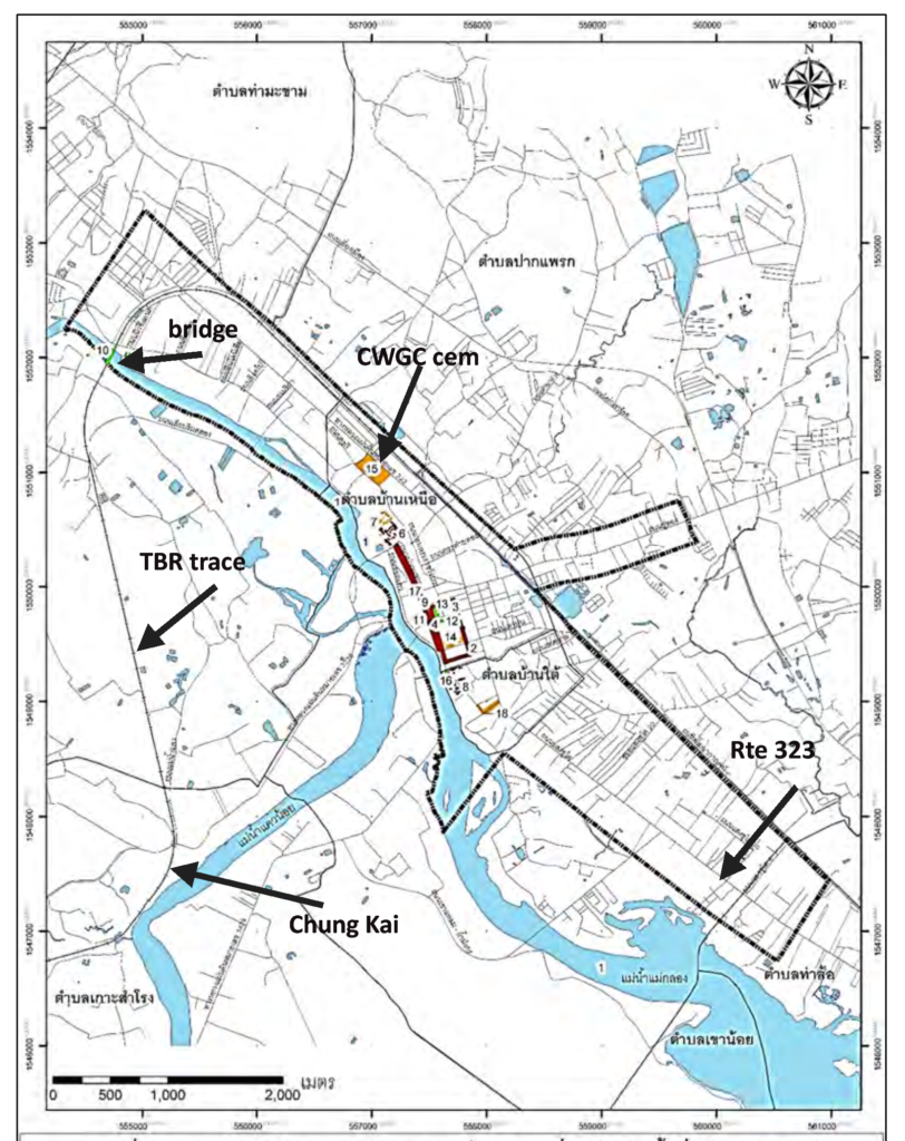
The decline of its former commercial dominance did not erase the historic character of the district. Instead, it allowed many elements of the older community to survive within the expanding modern city. Historic buildings, temples, remnants of the city wall, riverfront areas, streets, and established patterns of settlement continue to provide physical evidence of earlier periods.
The Old City contains three particularly important landmarks: Wat Thewa Sangkharam, Wat Chai Chumphon Chana Songkhram, and the Provincial City Pillar Shrine. Two historic monuments—the new city wall and Wat Songkhram (Wat Tai)—are registered by the Fine Arts Department as national historic monuments, while Wat Thewa Sangkharam has been surveyed and documented as an important historic site.
The historic environment also extends beyond individual monuments. Pak Phraek Road and Chuk Don Road retain groups of older buildings, while the river system, temples, streets, and remaining portions of the city wall contribute to the character of the historic district[6]. The city’s natural environment remains particularly significant because the Khwae Yai, Khwae Noi, and Mae Klong rivers have influenced settlement, transportation, commerce, and the landscape throughout the province’s history.
Kanchanaburi Old City is therefore best understood as a palimpsest[7]. Each period has left traces: the military frontier of earlier centuries, the fortified city established under Rama III, the Chinese and Vietnamese commercial community of the nineteenth century, the river-based economy, the Japanese occupation and wartime railway, and the postwar transition to a neighborhood within a growing modern city.
Looking to the Future
The future of Kanchanaburi Old City depends upon maintaining this historical continuity while allowing the city to remain a functioning community. The conservation guidelines emphasize that an old city should not be developed in the same manner as a new urban area. Economic development should not destroy the historic fabric[8]; instead, new development should be directed and managed so that the Old City can retain its distinctive atmosphere, cultural values, architectural character, and way of life.
A central concern is the protection of surviving historic buildings and the remaining evidence of the city’s original form. Development should respect the scale, proportions, materials, and character of older structures. The city wall and former moat areas should be made more legible, while inappropriate additions and alterations to historic buildings should be avoided. Where historic buildings can be retained and adapted to contemporary uses[9], adaptive reuse offers a means of keeping them part of the living community rather than treating them solely as museum objects.
The guidelines also envision a more pedestrian-oriented historic district. Improved walking and bicycle routes, reduced heavy traffic, and restrictions on large vehicles would help protect both the physical environment and the experience of the Old City. Routes connecting historic buildings, monuments, open spaces, and other important elements could allow visitors and residents to experience Kanchanaburi as a connected historic landscape rather than as a series of isolated sites.
Perhaps most importantly, conservation is presented as a community responsibility. Residents, students, scholars, local organizations, government agencies, and businesses all have a role in understanding and maintaining the historic environment. The preservation of local traditions, food, language, festivals, beliefs, and other forms of intangible heritage is considered as important as the preservation of buildings.
This approach is particularly appropriate for KAN because its history has always been a history of interaction: between river and road, military and commerce, Thai and immigrant communities, old and new architecture, and local life and international events. The objective of conservation should therefore not be to freeze Pak Phraek in a particular historical moment. It should be to ensure that the physical and cultural evidence of those successive periods remains visible and meaningful while the community continues to live and develop.
Kanchanaburi’s future will inevitably bring further change. The challenge is to ensure that change does not sever the connection between the modern city and the history that created it. If the surviving buildings, streets, temples, city-wall remnants, river landscapes, and living traditions can be preserved and interpreted within a functioning community[10], Kanchanaburi Old City can continue to serve as both a place of everyday life and an enduring record of the city’s remarkable past.
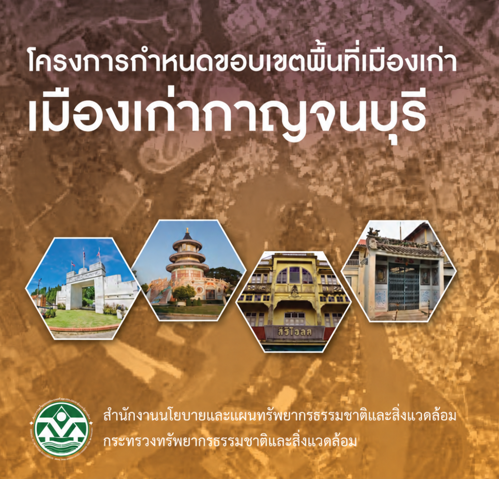
[1] Office of Natural Resources and Environmental Policy and Planning (ONEP), Ministry of Natural Resources and Environment, Kanchanaburi Old City [โครงการกำหนดขอบเขตพื้นที่เมืองเก่า: เมืองเก่ากาญจนบุรี], English translation of the basic document, pp. 9–48 prepared as part of the Old City Boundary and Conservation and Development Framework Project; approved by the Cabinet on July 31, 2018
[2] In Thai, Tai means south and Nuea, north
[3] The present shrine (located just inside the old city near the surviving City Gate) is not the original nineteenth-century building. The present structure was built in 1960, replacing the deteriorated earlier shrine. It is a Thai-style four-gabled pavilion, while the historical city pillar and the associated inscriptions remain the important documentary evidence.
[4] Wat Thaworn Wararam, commonly known as Wat Yuan, was established by Kanchanaburi’s Vietnamese community during the reign of King Rama III (1824–1851). The temple subsequently received its formal name, Thaworn Wararam, from King Chulalongkorn (Rama V). Its Chinese- and Vietnamese-influenced architecture reflects the cultural presence of the Vietnamese community in nineteenth-century Kanchanaburi.
[5] It is also worthy of note that the Vietnamese pressed into service as part of the romusha workforce were drawn from the established Vietnamese community living in the Wat Yuan area; they were not brought to Kanchanaburi by the Imperial Japanese Army.
[6] The only known TBR-related artifact within the Old City walls is preserved at the JEATH Museum, adjacent to Wat Tai, near the location identified in surviving records as the site of a small Allied POW cemetery.
[7] a place shaped by successive layers of human occupation, development, and memory, in which later landscapes and structures coexist with, obscure, or preserve traces of earlier ones. In the case of Kanchanaburi’s Old City, prehistoric settlement, the former frontier city, the nineteenth-century Pak Phraek community, and the physical and commemorative remain
[8] The contrast is particularly striking given the extensive commercial development and commodification associated with the bridge area, which have substantially altered or obliterated many TBR-related sites across the surrounding landscape.
[9] The principle is particularly relevant to Wat Thaworn Wararam (Wat Yuan), where recently a Nadukal (hero stone) has been paired with the 1957 Chedi Niranam. This illustrates the broader conservation challenge of introducing new commemorative elements into an established historic setting while retaining the architectural and historical character of the site.
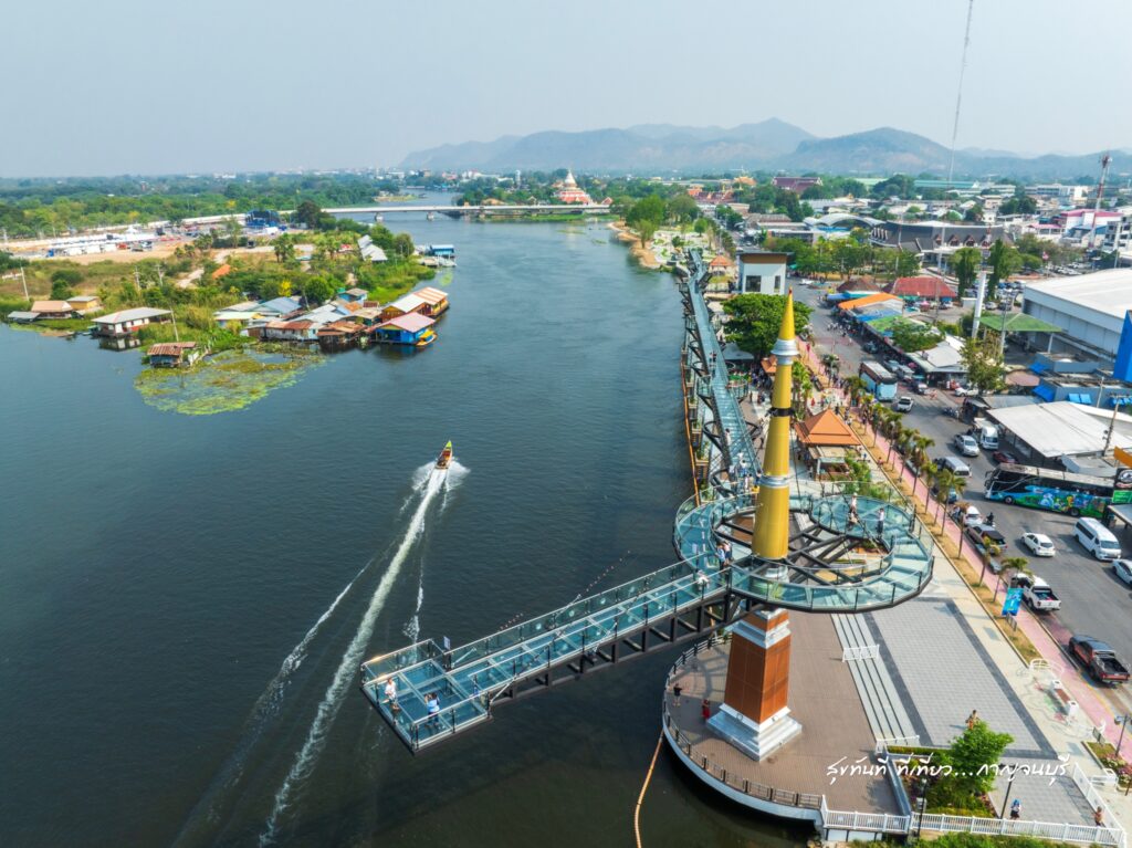
[10] A contemporary example is the Kanchanaburi Skywalk, opened in 2022 and substantially upgraded for continued public use in 2025. Located along the riverfront near the confluence of the Khwae Yai and Khwae Noi, the elevated glass walkway provides a new vantage point over the historic river landscape while forming part of a broader tourism and commercial development zone. The project illustrates both sides of the conservation challenge: such infrastructure can increase public access to and appreciation of the historic landscape and support local economic activity, but its associated commercial development also requires careful management if the character and historical continuity of the Old City are to be maintained.